
Our last installment took us as far as Presidio, TX, on November 6. Read on to learn about our next several steps.
Nov 7-8 (Wednesday, Thursday): We drove to Big Bend National Park near Cottonwood, TX. The drive from Presidio was described by our RV campground host as “the prettiest road in the US,” and she may very well have been right. We were awestruck by the breathtaking views along the narrow, winding, roller-coaster road as it followed the Rio Grande River, although Pat seemed to have turned a pale shade of green by the time we arrived at Big Bend. While her discomfort was due to motion sickness and trepidation over the steep drops next to the road, we were both more sickened by the thought of despoiling the beauty with a giant wall erected to salve the irrational fears of the anti-immigrant crowd. Perhaps if more people would come to look at this place, to gaze out across the river at the nonexistent hordes of imaginary invaders … but I digress.

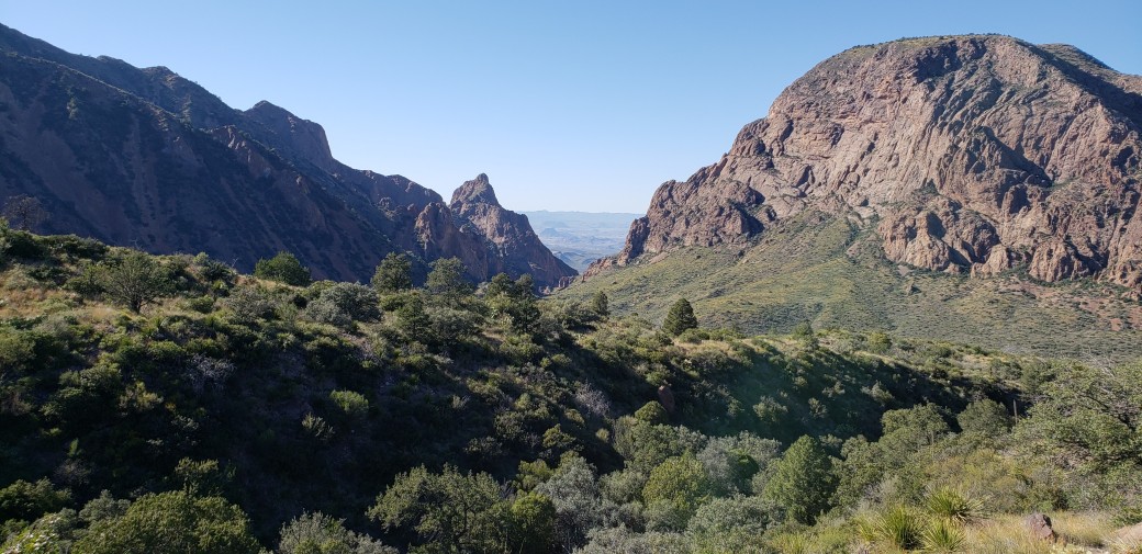
After our free entry into the park (with my National Parks Senior Card), we drove to the Chisos Basin Campground, located as implied in a large basin amidst the Chisos Mountains. By the time we had navigated the road into the campground with its multiple switchbacks, hairpin curves, and severe grades – first up and then down – Pat’s color had morphed into a frightening puce. But she immediately perked up when we found a vacant campsite – probably the most dramatic one we’ve had so far.

We paid a whopping $7 per night with my Senior Pass discount. There was no electricity, water, or sewer, so we were again dry camping / boondocking. The site was very uneven, and we couldn’t level out the camper with our existing stock of leveling blocks, so I felt a bit like a drunken sailor as I walked back and forth inside. It was also a grueling half-mile, uphill hike from the campground to the Visitor Center area, which included a store, a restaurant, and several lodges for non-camping guests. But none of that mattered as we hiked the scenic trails, covering about ten miles over the two days, or sat quietly in our lawn chairs drinking in the scenery. We had one nice lunch at the restaurant but prepared the rest of our meals in the RV. It was near freezing at night, but the daytime temperatures were very comfortable.

Nov 9-(Friday): We awoke to find the Chisos Basin campground shrouded in fog; temperature in the upper30s and a chill wind required our jackets when we were outside. We had intended to drive to the southeast corner of the park for scenic views of the Rio Grande, but after navigating the campground road in the fog, creeping along at a snail’s pace, barely able to see anything, we decided to just head off to our next destination. The fog persisted for a couple of hours as we wended our way toward El Paso, TX, and both of us were nervous wrecks from the tough driving conditions by the time the fog finally lifted. After some five hours of driving, we decided to stop at an RV Park in Van Horn, TX, where we payed $14 for a site with full hookups (with a Passport America discount). This place even had cable TV and, having procured a cable at Walmart a couple of days previously, we enjoyed a bit of junk TV. We took showers in their excellent facilities and were ready to go again in the morning.
Nov 10-11 (Saturday, Sunday): On Saturday we covered 370 miles from Van Horn to Willcox, AZ. The El Paso metro area freeway was jammed, requiring a relatively slow pace of 50 – 55 mph, but the rest of the trip was free sailing, with little traffic other than innumerable semi-trucks carrying America’s goods to market. The freeway spanned seemingly endless miles of flat desert areas, surrounded on all sides by distant mountains. Every so often we would actually reach the mountains ahead, at which points the road would wind up and down through a mountain pass and emerge once more into the desert, with mountains again far off in the distance. The drive was very easy, but I was impressed by the incredible vastness of the southwestern landscape. We stopped at another RV Park with full hookups, wi-fi, and cable TV, though the Passport America rate was not as good at $23 per night. So why did we stay two nights? There was a golf course only two miles away, so naturally I had to play on Sunday. I’ll say only two things about the golf: 1) it was a good deal at $17 for 18 holes with a rented pull cart, and 2) I really need those new irons.
Nov 12 (Monday): We drove about 40 miles to the Chiricahua National Monument, named for the Chiricahua Apache tribe who occupied the area from the 1500s until being driven out by white American settlers and the US Army in the 1880s after some 50 years of warfare. The area was named a National Monument in 1923, to protect the unique and beautiful rock formations. RVs larger than 29 feet are not allowed due to the narrow, winding roads, but we easily navigated our 25-foot Unity into the Bonita Canyon Campground, where we had actually reserved a spot for a change. It cost $10 for a gorgeous site with no hookups.

We took a nice, 4-mile hike through the Riparian zone of the park past some historic structures collectively known as Faraway Ranch – since it was so far away from any place else – which in addition to being a working cattle ranch provided lodging for park visitors from 1917 to 1973. Interestingly, the place was founded by Swedish immigrants after the Native people had been driven away to reservations in Florida and Oklahoma.

Nov 13 (Tuesday): We drove the RV from our beautiful campsite to the Visitor Center and parked there so we could take the free hikers’ shuttle to the trailheads near the top of the mountain, along with three other hikers. The narrow, winding, 6.5-mile-long road with a vertical climb from 5400 ft elevation at the Visitor Center to 6780 ft at the trailhead might have been a challenge in the RV. We then spent about two and a half hours descending along the Echo Canyon, Upper Rhyolite Canyon, and Lower Rhyolite Canyon trails, a total distance of 4.2 miles. The hike began with spectacular vistas highlighted by the fantastical rock formations that have been carved out f the rhyolite rock originally laid down millions of years ago as volcanic ash. It was about 35-40 degrees, with a severe wind, so we needed to wear stocking caps and gloves to keep from freezing, but we hardly noticed because the sights were so incredibly beautiful. Gradually, the trail habitat morphed from the Mountain Zone back to the Riparian Zone, showcasing the incredible diversity of flora and fauna this gem of a park has to offer, and the temperature rose to a more comfortable mid-50s.


After the hike, we headed off to the west again, stopping for the day at an RV park in Benson, AZ, which had excellent and much needed laundry and shower facilities along with full hookups for the RV (all for a rate of $25 per night with our Passport America discount).
The next phase of our trip will take us to some slightly different environs than the beautiful borderlands – check back in a week or so for the next update …

Skip the irons. I need every edge I can get….
LikeLike